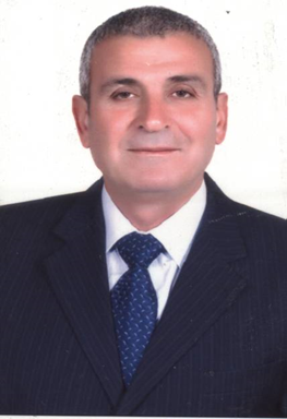
Prof. Dr. Adib Mahmoud Al-Qamou'
Surveying and Geodesy
Scientific Rank Professor
Tasks
Professors - Department of Topographic Engineering Faculty Of Civil Engineering
Certificates en
1978
Bachelor's degree in Civil Engineering (B.Sc.), Tishreen University – Lattakia
1989
Ph.D. Engineering Surveying & Geodesy Bulgaria - Sofia
Academic Experiences en
1989
1989 - 1993, Teaching as a Lecturer and head of the Department of Topographic Engineering - Faculty of Civil Engineering - Tishreen University - Lattakia - Syria
2001
New Academic Experience
2007
Professor in the Department of Topographic Engineering – Faculty of Civil Engineering at Tishreen University
2008
Lecturer in the Department of Topographic Engineering – Faculty of Civil Engineering at the University of Aleppo, for the courses: Geodesy 2 and Cadastral Surveying, for the academic years 2008/2012.
1995
Research Paper: Monitoring Building Settlements in Soft Soil Areas in the City of Benghazi. The Sixth Arab Conference on Engineering Structures, Syria – Damascus, 21–24/10/1995.
2002
Research titled: Analysis of Coordinate Differences of a Triangulation Network Using Traditional Surveying Methods and the GPS System – Sofia, Bulgaria, 20–21/11/2002 (Bulgarian Language).
2007
Analytical Study of Geodetic Polygons Used for Topographic Surveying and Plotting, Aleppo University Research Journal, Engineering Sciences Series, Volume 53, 2007.
2009
Research Paper: The Cadastral Survey Network, the Basis for Determining Property Ownership. First Housing Conference (BATICOM), Moroni – Republic of the Comoros, 22–24/02/2009.
2014
Co-authored scientific paper: Artificial Intelligence and Global Navigation Systems in Improving the Use of Practical Life Applications. First World Conference on Civil Engineering – Tishreen University – Lattakia – Syria, August 2014.
2010
Research paper(corporate ): Hydrgraphical Works for Design and Construction of Hydrotechnial Projects on DANUBE RIVER. Digital Model of the Bottom. Tartous Port General Company, 28-30/04/2010
2010
- Research paper(corporate ) :Deformation monitoring of high buildings and engineering constructions by geodetic methods. Faculty of Civil Engineering , Tishreen University , Lattakia, Syria, 17-18/10/2010,
2011
– Research paper(corporate ) : Comparative the execution of topographic plans , with Total Stations (T.S.) and Global Positioning System(GPS). Bulgaria , Sofia 3-4 November 2011.
2011
Research paper (corporate ) : The importance of engineering's geodetically works, for the assembly and check-up the rails under cranes at the ports. Tartous Port General Company, 22-24/10/2011.
2011
- Research paper (corporate ) :Floating Triangulation & Establish Reference for Geographic Information System. Tartous Port General Company, 22-24/10/2011
2012
- Research paper(corporate ) : Performance Comparison of Three Second Order Extended KALMAN FILTER Algorithms in Hybrid Positioning. Bulgaria , Sofia 15-17 November 2012.
1998
Teaching Subjects: 1 – Surveying for Architecture, 2 - Cadastral Surveying ,. 3 – Engineering Surveying, 4 – Roads & Highways Surveying (PRACTICE), 5-Roads & Highways Surveying (THEORY),
Professional Experiences en
0
- Register the scientific research, title: Studies in modern methods of surveying and setting out using Total Stations(T.S.) and Global Navigation Satellite Systems (GNSS)in SYRIA.
2017
Register the Ph.D. in Topographic engineering title: Developing Ambiguity Resolution Algorithm in Precise Point Positioning within Global Navigation Satellite Systems
2002
Control with group for controlling project ring- road south Lattakia , Lattakia 2002 .
2002
- Control with group for controlling port road in Lattakia , Lattakia 2002 .
2004
Controlling designing of the Alderbasia bridge and Bulgarian bridge , General Directorate for roads , Damascus 2004
2004
Controlling designing of extension the bridges( No 4 , 6 , 8 ,9 )on the highway Tartous- Lattakia , General Directorate for roads , Damascus 2004
2004
Completion Topographic plan for the river Alsen stream from the spring to the Mediterranean Sea . Finishing cross-sections and profile for the stream of the river , General Directorate for the basin coast , Lattakia 2004 .
2004
Completion Topographic plan for the river Alsen stream from the spring to the Mediterranean Sea . Finishing cross-sections and profile for the stream of the river , General Directorate for the basin coast , Lattakia 2004
2005
- Designing for the project of ring-road Hamidie . General Directorate for roads , Damascus 2005 .
2011
Technical study and prepare a dossiers of appropriation of the road: Safita- Alghamka- Algarwia- ….up to general road Safita- Drikish. Tartous – 2011
1977
New Professional Experience
0
New Professional Experience
2010
New Professional Experience
2010
New Professional Experience
2014
New Professional Experience
1998
New Professional Experience